
| Kind of Adventure | Kilometers | Level of Difficulty |
| Hiking | 38 | Strenuous |


Las Vegas is not the place to be in August, it is just too hot. So are a lot of place around such as Death Valley, Valley of Fire, Joshua Tree National Park or the Mojave National Preserve. All places which are still on my bucket list but unsuitable on account of the season.
I did a lot of research and I soon realised, I had to go up into the mountains. I could have gone to Zion National Park in order to hike The Narrows again or to explore The Subway. But I had been there in May, so I wanted to go elsewhere. In one of my Utah Guidebooks, I found my destination: Cedar Breaks Monument, also called the little brother of Bryce Canyon NP. I love Bryce, so I was curious and at more than 3000 meters above sealevel, it sounded like exactly the right place to go hiking in August.
Like Bryce, Cedar Breaks NM is a dark sky sanctuary, another reason why I was attracted. I love to stargaze and the sky above 3000 meters is usually very clear. After I had chosen my destination, I need to then pick my activity. Of course, hiking was the obvious choice, but where to go? I did some more research and settled on hiking up the Ashdown Gorge, a narrow canyon with waterfalls which was hailed as the Little Narrows. There is a hike from the trailhead all the way up to the summit of Cedar Breaks NM approximately 15 km long but with a lot of elevation on the go. As I did not find a shuttle, I would need to hike it up and then back down again to reach back to my car. Wild camping is allowed anywhere inside the national forest, so I packed my hammock and sleeping bag.
I arrived in Las Vegas in the late afternoon and picked up my rental car from the airport. I stayed overnight in our hotel and set out to Cedar City early next morning. The weather forecast, which stated heavy rain till about midday and again a slight chance of rain the following day, got me slightly worried. As I planned hiking up a canyon, good weather was crucial as heavy rain would increase the risk of flash floods. I am not fearful, but I am not reckless either.
About 30 minutes before arriving, it started to rain. I drove the last kilometres through pouring rain. I did my shopping and them found myself a comfy cafe to take breakfast. The rain was scheduled to stop around midday and I spent the time till 12 in town, doing some shopping. Around 11:30 I drove up to the trailhead, little more than a gravelled shoulder on the main road up to Cedar Breaks NM. I would have missed it, had there not been two cars parked already.
I parked my car next to them and then prepared myself for the hike. Thanks to my hike down The Narrows, I still had my waterproofed backpack which would come in handy during this hike as well. I had decided on a pair of hiking boots this time as the greater part of this hike would be up the mountain and only the first and last part through the river. As the weather forecast had advertised a clear night, I had not packed a tent, only my hammock and sleeping bag. To be more comfortable I had brought a camping mat to put inside the hammock.
Everything fitted nicely in my backpack. The rain had almost stopped and I set out on my adventure. Going up all the way to an elevation of almost 3200 meters above sea level which meant an elevation difference of 1036 meters from the starting point. I would be a long day.
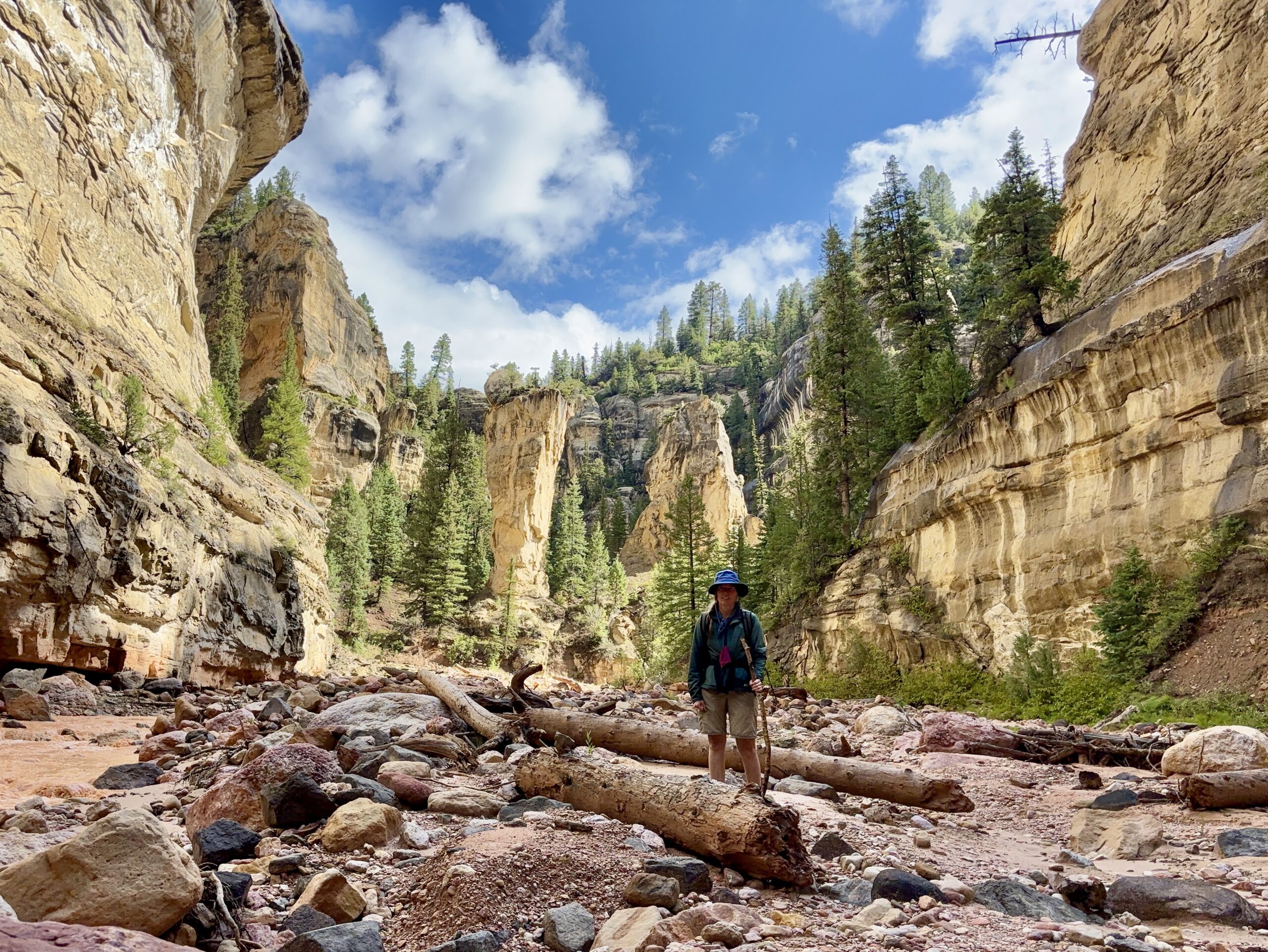
The first part of the hike leads through the Ashdown Creek and you are guaranteed to get your feet wet. The hike is often touted as The Narrows no. 2 but honestly, it is not really comparable. If you are looking for an experience similar The Narrows, you will be disappointed. The water of the creek is very muddy, the gorge does not close in as dramatically as The Narrows and after a couple of kilometres you will leave the rivers behind and ascent into the mountains. It is a totally different experience, not as special as The Narrows, but an amazing hike due to its own special character and beauty.
The first thing I noticed was the color of the water. It is muddy brown and it is not possible to see the bottom. That makes hiking through it even more difficult. The color comes from the sediments of the surrounding mountains and rocks as anyone can quickly perceive. The water was cold but not flowing to high, one of the things I had feared while driving up. But luckily there was no danger of a flash flood. The hike through the river was challenging but an experience I won’t forget. I had to climb over rocks, logs and some debris, so progress was slow. I was unconcerned as I still had a long day ahead of me and frankly, I could go as far as I wanted. If I would be to tired to make it all the way to the top, so be it. I soon entered the gorge with the walls rising up high. Not nearly as high and narrow as in The Narrows, but it is still pretty spectacular.
The first highlight is Flanagan’s Arch, one of Utah’s biggest freestanding stone arches. It is situated high up above the river and you need to keep an eye out for it, otherwise it is easily missed. It is not so spectacular as it is to far away and I have not found any path or way up to the arch.
Another highlight on the way is Tom’s Head, a freestanding rock monolith which marks the confluence of the Ashdown Creek and the Rattlesnake Creek. When you reach it, you have almost reached the end of the watery part of the trail. If you follow up Rattlesnake Creek, you can find a couple of interesting waterfalls. I was too impatient to be on my way on the first day and too tired to go up on my second. So I missed the waterfalls. But it is a reason to come back and do the hike one more time eventually.
I had almost hiked three hours when the trail finally left the river and turned uphill. The weather was cloudy but dry now and I got my hopes up for a bit of sunshine later that afternoon. But not I had to steadily hike up and the higher I got, the more strenuous it became. I first was surprised how much I tired but then I thought about the elevation which soon was above 2300 meters, and realised that it was not so unusual. I live in low altitudes all year round. Getting above 1000 meters is rare for me. I went on and tried to focus on my surroundings. Beautiful pine trees and some vistas of the distant mountains with cathedral like red rock formations on top for which Cedar Breaks is famous. I finally reached what was like an alpine meadow at 3000 meters. The views from there a just beautiful and I was able to see the beautiful red domes sitting on top of these mountains. Unfortunately the clouds started rolling in again and it started to lightly rain again. I soon ascended right into the clouds so visibility got very low. I soldiered on, my only goal now was to reach the top, a mere 200 high meters and few kilometres away. My legs got tired and had I stopped, it would have been chilly. My jacket and hat protected me from the drizzle, but it was definitely not very cosy up there. I don’t know how but I finally managed to reach the very top of the mountain after 8,5 hours of hiking. I had reached an altitude of 3190 meters above sea level and it was disappointing. The clouds obscured any view and the upper meadows were wet and unwelcoming. I had the feeling that any night spent here would not be comfortable. Still, I continue to the trail head just so I could say I had done it.
Then I decided to descend back to the meadow at 3000 meters which would provide me with trees for my hammock and some shelter from the wind. At least it had stopped raining and the clouds started to lighten so that there was like a mini sunset. It gladdened my heart and gave me some fresh energy to continue my descent. I still did not reach the meadow before nightfall. But as I had my headlamp, I could also continue in the growing darkness. Hiking through a forest in darkness is a curious thing. The mind conjures up dangers such as wild animals or ax murderers and one should definitely not let imagination run free.
Finally I reached the meadow. The sky was full of stars and I could see the Milky Way. Quickly I found myself two trees situated at the perfect distance for my hammock and set up my camp of the night. Once the sun had set, the air got chilly and the humidity did not help. I had a quick bite, then packed everything properly into my backpack and got into my sleeping back. It was cold but bearable. I remember still looking at the stars for a few minutes before I drifted off into sleep.
I was awaked rudely by as gust of wind around 3 am in the morning. Opening my eyes, the first thing I noticed was the lack of stars in the sky. I still remember thinking about that when the first drops of rain fell down on me. I was too sleepy to think straight but just tried to draw my hammock onto of me to shelter me from the rain. It did not help. Heavy rain set in and within twen minutes water enter my sleeping back from above and below. I tried to will away the harsh reality but as my feet and legs got wet, I finally realized, I needed to seek a better shelter. But where? The trees around me were pine and birch. Neither of which offer much shelter against rain. I finally crawled out of my hammock, took my sleeping bag and camping mat and took shelter underneath a pine tree. Wedging my camping mat on top of me through some branches to get a makeshift roof, I drew my now grippingly wet sleeping bag around me to stop myself from shivering. I sat on a log hoping the rain would stop. It did, two hours later around 5 am. I got back into my hammock as it was still dark and I did not want to risk setting out in the darkness. So I got back into my wet sleeping back and found another hour of cold and uneasy sleep.
I got up at dawn, changed into a dry trouser and stuffed everything into my backpack, wet or not wet. Then I set out. I was cold and miserable and berated myself for not bringing a tent. It was too late now. Soon I got warm by walking. Finally the sun rose out of the clouds and I decided to stop for a quick breakfast. It was at another meadow, further down, not far away from Ashdown Creek. If found myself a big rock and took out some cereal bars and and apple and just sat there enjoying the sunshine. I took off my jacket and tried to dry as much as possible.
Finally I got warm again and a bit cheerful. It is much easier to laugh about a night spent in a wet sleeping bag if you are warm and cosy. The rest of the way was much better. The sun came out in earnest and I was able to strip down to my T-Shirt. When I got back to the river I was bone tired but I felt the end of this strenuous adventure was near. Of course it was still three hours hiking through the creek, so it was still quite some time before I reached the car. I decided not to hike up to the waterfalls which would have meant a detour of 2 kms. I was just to exhausted for this extra distance. Hiking the river bed is tiring as there is no proper way or road. It is clambering over rocks and stones, always careful not to stumble and fall.
I was really glad to be back at Tom’s Head and then Flangan’s Arch and finally looking at the mountain which looks from this direction like the throne from the Game of Thrones series. Another 30 minutes and I was back at the parking lot where my car was standing all alone. What a relieve to get back, get out of the wet boots and put on dry clothes.
As I had not been able to enjoy any good views, I decided to drive up to where I had been the day before and have a nice hike on the rim of the amphitheatre. Cedar Breaks Nation Monument looks a little bit like Bryce Canyon. You can wander on op of it and look down to see the spectacular hoodoos and rock formations in red and white. It was my reward for last two days. Taking in the views from the rim was a once-in-a-lifetime experience. It was worth all the strains and pains of the last days and rewarded me richly.
I spent an hour walking and gazing, wearing a jacket as the wind was really chilly and temperatures just around 15 degrees Celsius up there before I finally drove back to hot Las Vegas.
Would I do it again? Definitely! Maybe not hiking the whole up and down but I would love to hike it from top to bottom and explore the waterfalls of Rattlesnake Creek next time. And camp further down the trail maybe in a proper tent.
Preparations
The good thing about this hike is, you need no permits, there will be few people and it does not cost you anything. Only going up to the rim by car, will require you to pay the entrance fee or have an America the Beautiful Card.
The whole hike from bottom to top and back down are 38 km, one way the map says 15,2 km but bear in mind, there is no straight way through the river.
If you want to hike it one direction only, you will need to cars, to drop one at the end of the trail or arrange for a shuttle.
You are allowed to camp anywhere in the national forest section of the trail which is pretty much everywhere except for the upper reaches. There are even designated campsites on the lower parts with places to put a campfire and logs to sit on.
Parking is possible on both ends of the trail and is free of charge.
The trail leads through mountains into high altitudes so it is important to check weather forecasts. Also there is the risk of flash floods after heavy rains. I was very much aware of that when I did the hike, but luckily did not encounter these dangerous conditions.
I
Pack List/Important Things to consider before
- Camping gear
- Suitable shoes/boots which are quick to dry but give you a secure footing
- Hiking pole
- Waterproof backpack
- Warm clothes for cold or damp nights (check-out the forecast and keep in mind that the inside of the canyon is colder than the surrounding countryside)
- Enough water to last for the entire hike
- Waterproof cellphone case
- Neoprene socks in case of cold temperatures
- Dry pants or or suit (if you attempt the hike during colder months)
All in all, it was definitely a lifetime adventure and I can recommend it for anyone who loves hiking and does mind getting their feet wet!
I found this map which only shows the lower part, but the tips are definitely helpful!
